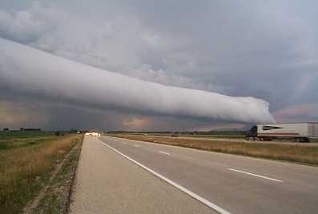
Figure 1 – A classic example of a roll cloud. Photgraph from the US NOAA and in the public domain.
I posted recently about cloud photography, and the night that I wrote the post I saw a clip on the NBC Nightly News showing a so-called “roll cloud” spotted and filmed over Texas. The Texas roll cloud is, I think, best viewed as a video. But I have included as Figure 1 a from NOAA. There is also a really impressive image from the United States National Weather Service showing a roll cloud forming in Sterling, VA, Figure 2.
Roll clouds are really rare. They are a form of arcus cloud. These are low forming horizontal clouds. The other major form of Arcus Cloud is the shelf cloud. While they appear to be horizontal tornados, they are, in fact, not related to tornadoes at all. They are caused by convective down draft at the leading edge of frontal systems.
So now I want to see and photograph my own. And I am still waiting to see mammatus clouds as well.
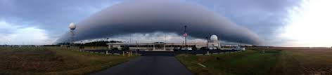
Figure 2 – Roll cloud forming over Sterling, VA. From the US National Weather Service and in the public domain.